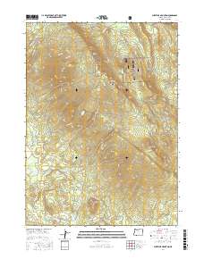
2017 Map of Surveyor Mountain
USGS Topo · Published 2017About this map
The Winema National Forest encompasses this high-elevation region of Klamath County, dominated by the peaks of the Cascade Range. High points like Surveyor Mountain, Kent Peak, and Surveyor Peak define the terrain, while geological features such as the Rock Slide reflect the area's volcanic and erosional history. Water management is a central theme of the landscape, evidenced by the presence of Lower Sheepy Reservoir, Sheepy Reservoir, and Parker Reservoir, which capture runoff from the surrounding slopes.
Find a feature on this map
54 named features on this map. Tap any name to fly to it.
Don’t see what you’re looking for? This feature index may not catch every label — zoom into the map to look around manually.
Map Details
Editions of this 2017 Surveyor Mountain Map
This is the sole edition of this map. No revisions or reprints were ever made.
Other maps of this area

1891 · Ashland
USGS Topo · 1:250,000

1893 · Ashland
USGS Topo · 1:250,000

1897 · Ashland
USGS Topo · 1:250,000

1955 · Lake O' Woods
USGS Topo · 1:62,500

1955 · Surveyor Mtn
USGS Topo · 1:62,500

1955 · Hyatt Reservoir
USGS Topo · 1:62,500

1955 · Mt. Mc Loughlin
USGS Topo · 1:62,500

1955 · Medford
USGS Topo · 1:250,000

1957 · Medford
USGS Topo · 1:250,000

1958 · Medford
USGS Topo · 1:250,000