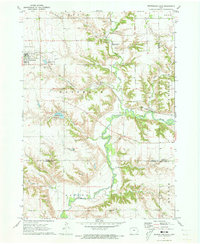
1971 Map of Sutherland East
USGS Topo · Published 1973About this map
Sutherland serves as the primary hub in this northwestern Iowa landscape, where the agricultural grid is interrupted by the deep, winding valley of the Little Sioux River. The map captures the convergence of several significant waterways, including Waterman Creek, Murray Creek, and Henry Creek, which carve distinct drainage patterns through the terrain. This 1971 field check documents a period when the Chicago and North Western railroad remained a vital transit artery for the region, cutting diagonally across the prairie north of town.
Find a feature on this map
23 named features on this map. Tap any name to fly to it.
Don’t see what you’re looking for? This feature index may not catch every label — zoom into the map to look around manually.
Map Details
Editions of this 1971 Sutherland East Map
This is the sole edition of this map. No revisions or reprints were ever made.
Other maps of this area

1954 · Fairmont
USGS Topo · 1:250,000

1954 · Fort Dodge
USGS Topo · 1:250,000

1957 · Fort Dodge
USGS Topo · 1:250,000

1958 · Fort Dodge
USGS Topo · 1:250,000

1958 · Fairmont
USGS Topo · 1:250,000

1964 · Gaza
USGS Topo · 1:24,000

1970 · Hartley SW
USGS Topo · 1:24,000

1970 · Royal
USGS Topo · 1:24,000

1971 · Peterson SW
USGS Topo · 1:24,000

1971 · Peterson SE
USGS Topo · 1:24,000