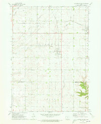
1971 Map of Sutherland West
USGS Topo · Published 1973About this map
The town of Sutherland and the village of Calumet anchor this Northwestern Iowa landscape, situated along the Chicago and North Western rail line. The map highlights a typical agricultural grid of the early 1970s, shaped by the drainage patterns of Willow Creek, Nelson Creek, and Gray Creek. Significant local landmarks include the Liberty Cem and a prominent Radio Tower near the border of O'Brien Co and Cherokee Co. This survey reveals the industrial and infrastructure markers of the era, from the various Gravel Pits to the water and utility infrastructure servicing these rural communities. The map provides a clear record of the townships including Liberty, Cedar, and Amherst as they appeared just before further modernization of the regional transport network.
Find a feature on this map
21 named features on this map. Tap any name to fly to it.
Don’t see what you’re looking for? This feature index may not catch every label — zoom into the map to look around manually.
Map Details
Editions of this 1971 Sutherland West Map
This is the sole edition of this map. No revisions or reprints were ever made.
Other maps of this area

1954 · Fairmont
USGS Topo · 1:250,000

1954 · Fort Dodge
USGS Topo · 1:250,000

1957 · Fort Dodge
USGS Topo · 1:250,000

1958 · Fort Dodge
USGS Topo · 1:250,000

1958 · Fairmont
USGS Topo · 1:250,000

1964 · Primghar
USGS Topo · 1:24,000

1964 · Gaza
USGS Topo · 1:24,000

1969 · Cleghorn
USGS Topo · 1:24,000

1970 · Hartley SW
USGS Topo · 1:24,000

1971 · Peterson SW
USGS Topo · 1:24,000