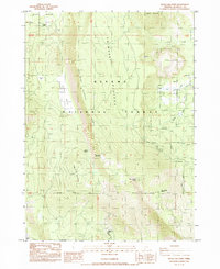
1985 Map of Swan Lake Point
USGS Topo · Published 1985About this map
Winema National Forest dominates this section of Klamath County, where the high-altitude terrain is defined by the massive Yawhee Plateau and Winema Plateau. The landscape is a network of ridges and water sources, centered on the prominent Swan Lake Mountain and Swan Lake Point. Near the summit of the point, the presence of the Swan Lake Point LO and a Radio Facility indicates the strategic importance of this high ground for regional communication and fire observation during the mid-1980s.
Find a feature on this map
29 named features on this map. Tap any name to fly to it.
Don’t see what you’re looking for? This feature index may not catch every label — zoom into the map to look around manually.
Map Details
Editions of this 1985 Swan Lake Point Map
This is the sole edition of this map. No revisions or reprints were ever made.
Other maps of this area

1889 · Klamath
USGS Topo · 1:250,000

1894 · Klamath
USGS Topo · 1:250,000

1955 · Klamath Falls
USGS Topo · 1:250,000

1956 · Calimus Butte
USGS Topo · 1:62,500

1957 · Chiloquin
USGS Topo · 1:62,500

1957 · Swan Lake
USGS Topo · 1:62,500

1957 · Modoc Point
USGS Topo · 1:62,500

1958 · Klamath Falls
USGS Topo · 1:250,000

1980 · Williamson River
USGS Topo · 1:100,000
1985 · Modoc Point
USGS Topo · 1:24,000