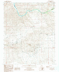
1990 Map of Swansea
USGS Topo · Published 1990About this map
The Swansea Old RR Grade cuts through a landscape defined by industrial history and the arid boundary between the Buckskin Mountains and the Rawhide Mountains. This 1990 provisional map documents the remnants of the copper mining era at Swansea, where the townsite is surrounded by numerous Prospects, Mine Shafts, and an unnamed Cem. The settlement’s infrastructure is clearly visible, including the Swansea Pumping Sta positioned along the Bill Williams River to the north, highlighting the critical importance of water transport in this desert environment. Further exploration of the terrain reveals natural landmarks like Clara Peak and a Natural Arch, while an Aboveground Pipeline and the Lincoln Ranch Road indicate more contemporary use of the land. The presence of both Mohave and La Paz county lines adds another layer of administrative history to this former mining hub.
Find a feature on this map
19 named features on this map. Tap any name to fly to it.
Don’t see what you’re looking for? This feature index may not catch every label — zoom into the map to look around manually.
Map Details
Editions of this 1990 Swansea Map
This is the sole edition of this map. No revisions or reprints were ever made.
Other maps of this area

1923 · Signal
USGS Topo · 1:250,000

1942 · Signal
USGS Topo · 1:250,000

1950 · Prescott
USGS Topo · 1:250,000

1954 · Prescott
USGS Topo · 1:250,000

1958 · Prescott
USGS Topo · 1:250,000

1959 · Prescott
USGS Topo · 1:250,000

1960 · Prescott
USGS Topo · 1:250,000

1965 · Prescott
USGS Topo · 1:250,000
1966 · Swansea
USGS Topo · 1:62,500

1966 · Ives Peak
USGS Topo · 1:62,500