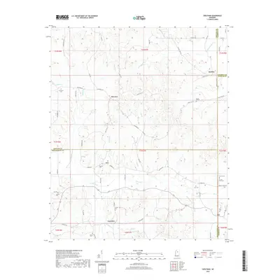
2018 Map of Sweatman
USGS Topo · Published 2018About this map
Sweatman and Alva are the primary focal points of this northern Mississippi landscape, where the borders of Montgomery, Grenada, Calhoun, and Webster counties converge. The terrain is defined by a dense network of watercourses including Little Bogue, Butputter Creek, and Redgrass Creek, which dictate the winding paths of rural connectors like Sweatman Road and Alva Road. Smaller settlements such as Lilac, Misterton, and Redding are interspersed throughout the interior, often marked by local crossroads or family-named landmarks.
Find a feature on this map
69 named features on this map. Tap any name to fly to it.
Don’t see what you’re looking for? This feature index may not catch every label — zoom into the map to look around manually.
Map Details
Editions of this 2018 Sweatman Map
This is the sole edition of this map. No revisions or reprints were ever made.
Other maps of this area

1953 · Walthall
USGS Topo · 1:62,500

1953 · West Point
USGS Topo · 1:250,000

1954 · Pittsboro
USGS Topo · 1:62,500

1954 · Duck Hill
USGS Topo · 1:62,500

1955 · Coffeeville
USGS Topo · 1:62,500

1958 · West Point
USGS Topo · 1:250,000

1963 · West Point
USGS Topo · 1:250,000
1983 · Eskridge
USGS Topo · 1:24,000
1983 · Duck Hill
USGS Topo · 1:24,000
1983 · Cadaretta
USGS Topo · 1:24,000