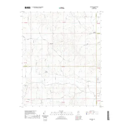
2020 Map of Sweatman
USGS Topo · Published 2020About this map
Sweatman and the surrounding borderlands of Montgomery, Grenada, and Webster Counties are defined by a dense network of creek valleys and family burial grounds. The settlement of Alva sits at a crossroads in the southeast, while small rural clusters like Misterton and Lilac are linked by winding roads such as Misterton Rd and Harmony Rd. This landscape is particularly notable for its high concentration of cemeteries, including the Harmony Cem Cox and Carver Cem and Providence Cem, which serve as vital markers for genealogical research in this part of Mississippi. Drainage patterns here are dominated by the Little Bogue and its tributaries, including Dunn Cr and Coffe Br, which carve through the terrain and dictated the placement of early homes and crossings like the Alva Stage Rd.
Find a feature on this map
68 named features on this map. Tap any name to fly to it.
Don’t see what you’re looking for? This feature index may not catch every label — zoom into the map to look around manually.
Map Details
Editions of this 2020 Sweatman Map
This is the sole edition of this map. No revisions or reprints were ever made.
Other maps of this area

1953 · Walthall
USGS Topo · 1:62,500

1953 · West Point
USGS Topo · 1:250,000

1954 · Pittsboro
USGS Topo · 1:62,500

1954 · Duck Hill
USGS Topo · 1:62,500

1955 · Coffeeville
USGS Topo · 1:62,500

1958 · West Point
USGS Topo · 1:250,000

1963 · West Point
USGS Topo · 1:250,000
1983 · Eskridge
USGS Topo · 1:24,000
1983 · Duck Hill
USGS Topo · 1:24,000
1983 · Cadaretta
USGS Topo · 1:24,000