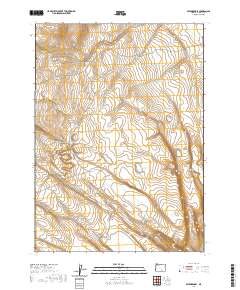
2020 Map of Swede Knoll
USGS Topo · Published 2020About this map
Swede Knoll rises above a high-desert landscape in Lake County, where seasonal water and topographic depressions define the human and natural geography. The drainage of Deer Cr cuts through the western sections of the survey, leading toward the intermittent waters of Desert Lake and Thunderbird Lake in the south. This 2020 map documents the complex water table of the high plains, where features like Fitzgerald Lake, Twin Lakes, and Link Lake appear as distinct catchments in an otherwise arid basin. The land is organized by the Public Land Survey System, showing the transitions between townships such as t36s r26e and t36s r27e. North of these basins, Robinson Draw provides a notable corridor through the higher elevations, illustrating the subtle but essential drainage patterns that have historically influenced grazing and land use in this part of Oregon.
Find a feature on this map
14 named features on this map. Tap any name to fly to it.
Don’t see what you’re looking for? This feature index may not catch every label — zoom into the map to look around manually.
Map Details
Editions of this 2020 Swede Knoll Map
This is the sole edition of this map. No revisions or reprints were ever made.
Other maps of this area

1955 · Adel
USGS Topo · 1:250,000

1957 · Adel
USGS Topo · 1:250,000

1958 · Adel
USGS Topo · 1:250,000

1962 · Adel
USGS Topo · 1:250,000

1967 · Jacobs Reservoir
USGS Topo · 1:24,000

1967 · Campbell Lake
USGS Topo · 1:24,000

1967 · Flook Lake
USGS Topo · 1:24,000

1967 · Alger Lake
USGS Topo · 1:24,000

1967 · Warner Peak
USGS Topo · 1:24,000

1967 · Swede Knoll
USGS Topo · 1:24,000