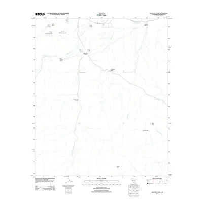
2012 Map of Sweeney Pass
USGS Topo · Published 2012About this map
The Great Sthrn Overland Stg Rt cuts across the northern landscape of this San Diego County quadrangle, marking a historical path through the desert near Carrizo Valley. The terrain is defined by a series of steep canyons and arid washes, including Bow Willow Canyon and Rockhouse Canyon, which drain into larger features like Carrizo Cr and Jojoba Wash. High points such as Egg Mountain and the Volcanic Hills overlook a region where water sources are critical, evidenced by the Mountain Palm Springs Area and its adjacent Mountain Palm Springs Campground. To the south, Indian Hill and the Smoke Tree Forest provide distinctive botanical and geological landmarks. This 2012 survey illustrates the modern road network, including Sweeny Rd and Sweeney Pass Rd, as they navigate the descent through Sweeney Pass.
Find a feature on this map
24 named features on this map. Tap any name to fly to it.
Don’t see what you’re looking for? This feature index may not catch every label — zoom into the map to look around manually.
Map Details
Editions of this 2012 Sweeney Pass Map
This is the sole edition of this map. No revisions or reprints were ever made.
Other maps of this area

1931 · Carrizo
USGS Topo · 1:125,000

1939 · Campo
USGS Topo · 1:62,500

1939 · Jacumba
USGS Topo · 1:62,500

1942 · Campo
USGS Topo · 1:62,500

1942 · Carrizo Mtn
USGS Topo · 1:62,500

1942 · Jacumba
USGS Topo · 1:62,500

1942 · Cuyapaipe
USGS Topo · 1:62,500

1950 · San Diego
USGS Topo · 1:250,000

1954 · San Diego
USGS Topo · 1:250,000

1955 · San Diego
USGS Topo · 1:250,000