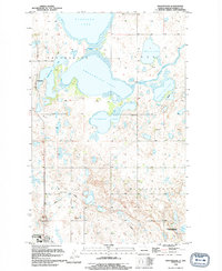
1994 Map of Sweetwater
USGS Topo · Published 1994About this map
Sweetwater Lake and a sprawling network of interconnected prairie basins dominate this Ramsey County landscape during the early 1990s. The small settlement of Sweetwater sits on the western edge of the quadrangle, serving as a landmark in a region defined by its hydrography. The map illustrates a complex water system where Morrison Lake, Freshwater Lake, and Storman Lake are linked by narrow channels and topographical depressions. A notable point of navigation within this aquatic maze is Gordons Pass, which connects the larger bodies of water. To the east, Barton Lake and Ringstrom Lake are joined by the winding Edmore Coulee, reflecting the natural drainage patterns characteristic of the North Dakota plains. The detailed topography reveals the subtle elevation changes that dictate how these lakes expand and contract across the prairie.
Find a feature on this map
9 named features on this map. Tap any name to fly to it.
Don’t see what you’re looking for? This feature index may not catch every label — zoom into the map to look around manually.
Map Details
Editions of this 1994 Sweetwater Map
This is the sole edition of this map. No revisions or reprints were ever made.
Other maps of this area

1931 · Devils Lake
USGS Topo · 1:62,500

1950 · Devils Lake
USGS Topo · 1:62,500

1951 · Crary
USGS Topo · 1:24,000

1951 · Devils Lake
USGS Topo · 1:24,000

1951 · Grand Harbor
USGS Topo · 1:24,000

1951 · Camp Grafton
USGS Topo · 1:24,000

1951 · Sweetwater
USGS Topo · 1:24,000

1953 · Devils Lake
USGS Topo · 1:250,000

1956 · Devils Lake
USGS Topo · 1:250,000

1957 · Starkweather SE
USGS Topo · 1:24,000