
1951 Map of Sweetwater
USGS Topo · Published 1951About this map
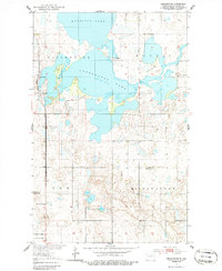
Sweetwater Lake and Morrison Lake dominate the northern landscape of this Ramsey County survey, which was conducted as part of the Department of the Interior program for the development of the Missouri River Basin. The small settlement of Sweetwater is situated along the Great Northern railroad line, which runs north-south through the western portion of the quadrangle.
Find a feature on this map
13 named features on this map. Tap any name to fly to it.
Don’t see what you’re looking for? This feature index may not catch every label — zoom into the map to look around manually.
Map Details
Editions of this 1951 Sweetwater Map
2 editions found
Other maps of this area

1931 · Devils Lake
USGS Topo · 1:62,500

1950 · Devils Lake
USGS Topo · 1:62,500

1951 · Crary
USGS Topo · 1:24,000

1951 · Devils Lake
USGS Topo · 1:24,000

1951 · Grand Harbor
USGS Topo · 1:24,000

1951 · Camp Grafton
USGS Topo · 1:24,000

1953 · Devils Lake
USGS Topo · 1:250,000

1956 · Devils Lake
USGS Topo · 1:250,000

1957 · Starkweather SE
USGS Topo · 1:24,000

1957 · Webster
USGS Topo · 1:24,000