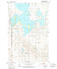
1951 Map of Sweetwater
USGS Topo · Published 1986About this map
Morrison Lake and the complex waters of Sweetwater Lake dominate this Ramsey County landscape, revealing a hydrologic system of basins including Freshwater and Morris. The small settlement of Sweetwater sits along the Great Northern rail line, serving as a focal point for the surrounding prairie townships. Evidence of earlier rural density appears in the form of two decommissioned educational sites, School No 2 (Abandoned) and School No 1 (Abandoned), which mark the shifting population patterns of mid-century North Dakota. The presence of a Pumping Station and a Gravel Pit indicates the local infrastructure and industry required to maintain this water-rich agricultural region. To the south, the City Bdy line approaches the northern reaches of Devils Lake, showing the proximity of these smaller wetlands to the state's largest natural body of water.
Find a feature on this map
14 named features on this map. Tap any name to fly to it.
Don’t see what you’re looking for? This feature index may not catch every label — zoom into the map to look around manually.
Map Details
Editions of this 1951 Sweetwater Map
2 editions found
Other maps of this area

1931 · Devils Lake
USGS Topo · 1:62,500

1950 · Devils Lake
USGS Topo · 1:62,500

1951 · Crary
USGS Topo · 1:24,000

1951 · Devils Lake
USGS Topo · 1:24,000

1951 · Grand Harbor
USGS Topo · 1:24,000

1951 · Camp Grafton
USGS Topo · 1:24,000

1951 · Sweetwater
USGS Topo · 1:24,000

1953 · Devils Lake
USGS Topo · 1:250,000

1956 · Devils Lake
USGS Topo · 1:250,000

1957 · Starkweather SE
USGS Topo · 1:24,000