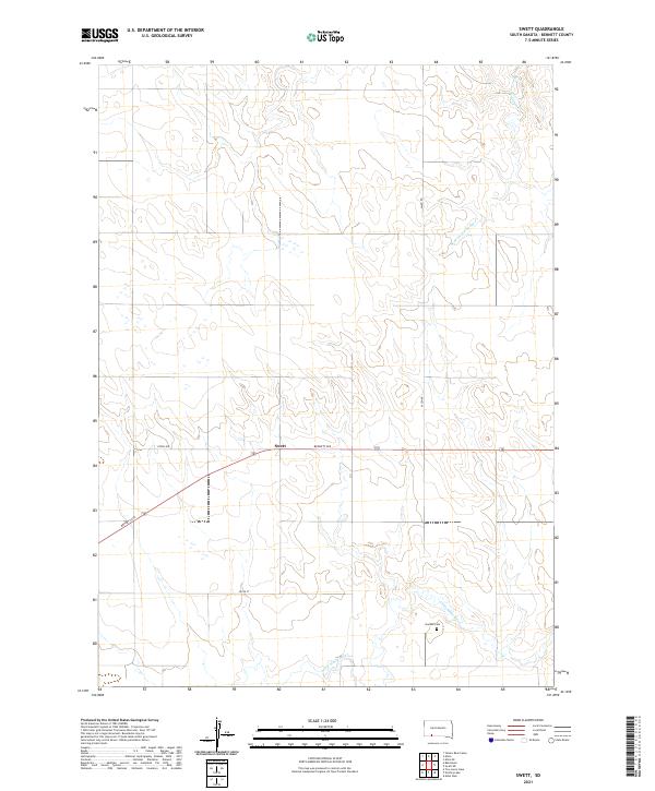
2021 Map of Swett
USGS Topo · Published 2021About this map
Swett serves as the central point of reference in this Bennett County landscape, situated at the junction of Bennett Ave and Allen Rd. This Western South Dakota prairie is defined by the drainage patterns of the Little White River, which cuts through the southern reaches of the quadrangle, and Bear-in-the-Lodge Cr to the northeast. A notable site for local history and genealogical research is the Gamble Cem, located on a rise overlooking the river valley. The map documents the section-line road network typical of the Great Plains, including 292nd Ave and 294th St, illustrating the enduring spatial organization of rural landholdings and transportation routes in this part of the state during the early twenty-first century.
Find a feature on this map
14 named features on this map. Tap any name to fly to it.
Don’t see what you’re looking for? This feature index may not catch every label — zoom into the map to look around manually.
Map Details
Editions of this 2021 Swett Map
This is the sole edition of this map. No revisions or reprints were ever made.
Other maps of this area

1955 · Hot Springs
USGS Topo · 1:250,000

1955 · Martin
USGS Topo · 1:250,000

1958 · Martin
USGS Topo · 1:250,000
1981 · Wakpamani
USGS Topo · 1:25,000

1981 · Yellow Bear Camp
USGS Topo · 1:25,000

1981 · Allen
USGS Topo · 1:25,000

1981 · Ecoffey Lake
USGS Topo · 1:25,000
1981 · Batesland
USGS Topo · 1:25,000

1981 · Swett
USGS Topo · 1:25,000

1983 · Martin
USGS Topo · 1:100,000