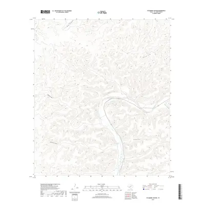
2019 Map of Sycamore Canyon
USGS Topo · Published 2019About this map
The Devils River carves a deep, winding path through this portion of Val Verde County, defining the drainage patterns of an intricate canyon system. This modern topographic study reveals the sparse water sources essential to the region, most notably Pecan Springs and Hudspeth Springs, which appear along the river's edge. The landscape is dominated by heavy dissection from seasonal waterways, including the prominent Sycamore Canyon to the west and Phillips Draw in the northeast. This territory remains largely undeveloped, with the topographic lines tracing the steep gradients of Wallace Canyon and Trail Canyon. The lack of named settlements reflects the arid, ranching-oriented nature of this Southwest Texas borderland, where life and geography are dictated by the presence or absence of water in draws like Brushy Draw and Mud Canyon.
Find a feature on this map
12 named features on this map. Tap any name to fly to it.
Don’t see what you’re looking for? This feature index may not catch every label — zoom into the map to look around manually.
Map Details
Editions of this 2019 Sycamore Canyon Map
This is the sole edition of this map. No revisions or reprints were ever made.
Other maps of this area

1943 · Shumla
USGS Topo · 1:62,500

1944 · Baker Crossing
USGS Topo · 1:62,500

1954 · Sonora
USGS Topo · 1:250,000

1958 · Sonora
USGS Topo · 1:250,000

1958 · Del Rio
USGS Topo · 1:250,000

1964 · Del Rio
USGS Topo · 1:250,000

1970 · Juno
USGS Topo · 1:24,000

1970 · Steel Star Draw
USGS Topo · 1:24,000

1970 · Sycamore Canyon
USGS Topo · 1:24,000

1970 · Blue Hills
USGS Topo · 1:24,000