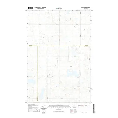
2014 Map of Sykeston SW
USGS Topo · Published 2014About this map
New Home Cem marks a lonely cultural point in this section of the North Dakota plains, situated near the intersection of 10th St SE and 52nd Ave SE. This 2014 survey reveals a landscape dominated by the jurisdictional meeting of three counties. The triple-border junction where Wells Co Kidder Co, Wells Co Stutsman Co, and Kidder Co Stutsman Co converge forms the primary administrative framework for this rural quadrangle. The terrain is characterized by a dense network of sectional roads, including 50th Ave SE and 9th St SE, which grid the area to support the region's agricultural pattern. Small depressions and scattered water bodies are interspersed throughout the township plots, illustrating the prairie pothole topography of the northern plains.
Find a feature on this map
19 named features on this map. Tap any name to fly to it.
Don’t see what you’re looking for? This feature index may not catch every label — zoom into the map to look around manually.
Map Details
Editions of this 2014 Sykeston SW Map
This is the sole edition of this map. No revisions or reprints were ever made.
Other maps of this area

1951 · Heaton
USGS Topo · 1:24,000

1951 · Dover
USGS Topo · 1:24,000

1951 · Sykeston
USGS Topo · 1:24,000

1952 · New Rockford
USGS Topo · 1:250,000

1956 · New Rockford
USGS Topo · 1:250,000

1971 · New Rockford
USGS Topo · 1:250,000

1972 · Woodworth
USGS Topo · 1:24,000

1972 · Lake Williams
USGS Topo · 1:24,000
1972 · Woodworth NW
USGS Topo · 1:24,000
1978 · Bowdon SE
USGS Topo · 1:24,000