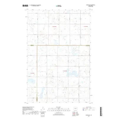
2018 Map of Sykeston SW
USGS Topo · Published 2018About this map
New Home Cem serves as a quiet landmark at the intersection of three North Dakota counties, where the boundaries of Wells, Kidder, and Stutsman meet. This 2018 survey reveals a landscape defined by an extensive network of section-line roads, including Co Hwy 69, which facilitates movement across this agricultural prairie. The terrain is characterized by numerous small wetlands and prairie potholes that dot the townships, particularly around 7th St SE and 8th St SE. The map illustrates a region where the traditional grid system of the Great Plains remains the primary organizational structure for travel and land division, reflecting the enduring legacy of the Public Land Survey System in rural North Dakota.
Find a feature on this map
22 named features on this map. Tap any name to fly to it.
Don’t see what you’re looking for? This feature index may not catch every label — zoom into the map to look around manually.
Map Details
Editions of this 2018 Sykeston SW Map
This is the sole edition of this map. No revisions or reprints were ever made.
Other maps of this area

1951 · Heaton
USGS Topo · 1:24,000

1951 · Dover
USGS Topo · 1:24,000

1951 · Sykeston
USGS Topo · 1:24,000

1952 · New Rockford
USGS Topo · 1:250,000

1956 · New Rockford
USGS Topo · 1:250,000

1971 · New Rockford
USGS Topo · 1:250,000

1972 · Woodworth
USGS Topo · 1:24,000

1972 · Lake Williams
USGS Topo · 1:24,000
1972 · Woodworth NW
USGS Topo · 1:24,000
1978 · Bowdon SE
USGS Topo · 1:24,000