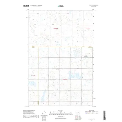
2020 Map of Sykeston SW
USGS Topo · Published 2020About this map
Glacial prairie potholes and marshy wetlands define this section of the Great Plains where Wells, Kidder, and Stutsman counties meet. The landscape is structured by a strictly rectilinear grid of local roads, such as 50th Ave SE and 11th St SE, which facilitate the region's agricultural production. For genealogists and local historians, two distinct burial sites serve as primary landmarks in this sparsely populated area: the New Home Seventh - Day Adventist Cem and the New Home Cem further south. These sites, situated near Co Hwy 69, reflect the early settlement patterns and religious heritage of the farming communities that established themselves on this section of the Missouri Coteau. The map provides a precise record of the numerous unnamed water bodies that dominate the township sections, illustrating the intricate hydrology of central North Dakota.
Find a feature on this map
27 named features on this map. Tap any name to fly to it.
Don’t see what you’re looking for? This feature index may not catch every label — zoom into the map to look around manually.
Map Details
Editions of this 2020 Sykeston SW Map
This is the sole edition of this map. No revisions or reprints were ever made.
Other maps of this area

1951 · Heaton
USGS Topo · 1:24,000

1951 · Dover
USGS Topo · 1:24,000

1951 · Sykeston
USGS Topo · 1:24,000

1952 · New Rockford
USGS Topo · 1:250,000

1956 · New Rockford
USGS Topo · 1:250,000

1971 · New Rockford
USGS Topo · 1:250,000

1972 · Woodworth
USGS Topo · 1:24,000

1972 · Lake Williams
USGS Topo · 1:24,000
1972 · Woodworth NW
USGS Topo · 1:24,000
1978 · Bowdon SE
USGS Topo · 1:24,000