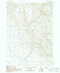
1990 Map of Syrup Creek
USGS Topo · Published 1991About this map
The Danskin Mountains dominate this high-desert landscape in the Boise National Forest, where a complex network of seasonal drainages and springs defines the local geography. Significant water features like Syrup Creek, Cottonwood Creek, and Canyon Creek carve through the terrain, supporting isolated infrastructure including a Gaging Sta and a Water Tank. The map reflects a working landscape of the late 20th century, where land use is marked by scattered Prospects and Borrow Pit excavations, alongside a prominent Trans Line crossing the southern portion of the sheet. The prevalence of named springs and intermittent creeks like Dry Creek underscores the importance of water management in this arid Idaho interior.
Find a feature on this map
24 named features on this map. Tap any name to fly to it.
Don’t see what you’re looking for? This feature index may not catch every label — zoom into the map to look around manually.
Map Details
Editions of this 1990 Syrup Creek Map
This is the sole edition of this map. No revisions or reprints were ever made.
Other maps of this area

1892 · Mountain Home
USGS Topo · 1:125,000

1893 · Mountain Home
USGS Topo · 1:125,000

1955 · Hailey
USGS Topo · 1:250,000

1956 · Crater Rings
USGS Topo · 1:24,000

1956 · Mountain Home North
USGS Topo · 1:24,000

1956 · Mountain Home
USGS Topo · 1:62,500

1959 · Hailey
USGS Topo · 1:250,000

1960 · Mayfield
USGS Topo · 1:62,500

1960 · Danskin Peak
USGS Topo · 1:62,500

1962 · Hailey
USGS Topo · 1:250,000