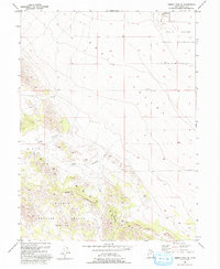
1993 Map of Tabbys Peak SE
USGS Topo · Published 1993About this map
The eastern slopes of the Cedar Mountains descend into the arid expanse of Skull Valley in this 1993 revision. This landscape is defined by its administrative and military boundaries, notably containing portions of the Skull Indian Reservation and the Dugway Proving Ground (Restricted Area). The geography is marked by distinct drainage patterns such as Wide Hollow and Post Hollow, which transition from the steep mountain terrain to the valley floor. To the north, the Hickman Knolls rise from the basin, providing a topographical break in the otherwise steady alluvial slope. The map's detail reflects the specialized use of this high-desert environment in the late twentieth century, where restricted military zones and tribal lands intersect with the natural landforms of the Great Basin.
Find a feature on this map
11 named features on this map. Tap any name to fly to it.
Don’t see what you’re looking for? This feature index may not catch every label — zoom into the map to look around manually.
Map Details
Editions of this 1993 Tabbys Peak SE Map
This is the sole edition of this map. No revisions or reprints were ever made.
Other maps of this area

1885 · Tooele Valley
USGS Topo · 1:250,000

1953 · Tooele
USGS Topo · 1:250,000

1954 · Camels Back Ridge NW
USGS Topo · 1:24,000

1955 · Tabbys Peak SE
USGS Topo · 1:24,000

1955 · Tabbys Peak
USGS Topo · 1:24,000

1955 · Camels Back Ridge NE
USGS Topo · 1:24,000

1955 · Davis Knolls
USGS Topo · 1:24,000

1955 · Deseret Peak
USGS Topo · 1:62,500

1955 · Tabbys Peak SW
USGS Topo · 1:24,000

1955 · Tooele
USGS Topo · 1:250,000