
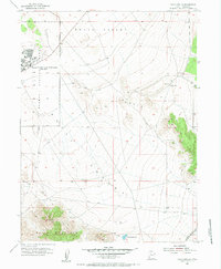
1955 Map of Davis Knolls
USGS Topo · Published 1956About this map
The Dugway Proving Ground occupies the western expanse of this mid-century survey, centered on the Dugway Proving Ground Headquarters (Easy Area). This military installation features a structured layout of roads, a High Sch, a Hospital, and a Landing Strip situated along the edge of the desert basin. The landscape is a study in transition between the flat floor of Skull Valley and the uplifted terrain of the Davis Knolls and Davis Mountain, where Round Top stands as a prominent landmark.
Find a feature on this map
18 named features on this map. Tap any name to fly to it.
Don’t see what you’re looking for? This feature index may not catch every label — zoom into the map to look around manually.
Map Details
Editions of this 1955 Davis Knolls Map
2 editions found
Other maps of this area

1885 · Tooele Valley
USGS Topo · 1:250,000

1953 · Tooele
USGS Topo · 1:250,000

1955 · Tabbys Peak SE
USGS Topo · 1:24,000

1955 · Simpson Springs
USGS Topo · 1:24,000

1955 · Indian Peaks
USGS Topo · 1:24,000

1955 · Camels Back Ridge NE
USGS Topo · 1:24,000

1955 · Deseret Peak
USGS Topo · 1:62,500

1955 · Tooele
USGS Topo · 1:250,000

1971 · Onaqui Mts South
USGS Topo · 1:24,000
1971 · Lookout Pass
USGS Topo · 1:24,000