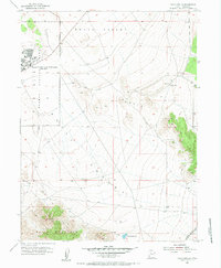
1955 Map of Davis Knolls
USGS Topo · Published 1984About this map
Dugway Proving Ground occupies the northwestern portion of this mid-century survey, specifically focused on the Dugway Proving Ground Headquarters (Easy Area). This military installation includes a dedicated Landing Strip, a Hospital, and a High Sch, indicating a self-contained community established for personnel and their families during the Cold War era. The surrounding terrain is defined by the broad expanse of Skull Valley and the distinctive topographic rises of the Davis Knolls and Davis Mountain.
Find a feature on this map
21 named features on this map. Tap any name to fly to it.
Don’t see what you’re looking for? This feature index may not catch every label — zoom into the map to look around manually.
Map Details
Editions of this 1955 Davis Knolls Map
2 editions found
Other maps of this area

1885 · Tooele Valley
USGS Topo · 1:250,000

1953 · Tooele
USGS Topo · 1:250,000

1955 · Tabbys Peak SE
USGS Topo · 1:24,000

1955 · Simpson Springs
USGS Topo · 1:24,000

1955 · Indian Peaks
USGS Topo · 1:24,000

1955 · Camels Back Ridge NE
USGS Topo · 1:24,000

1955 · Davis Knolls
USGS Topo · 1:24,000

1955 · Deseret Peak
USGS Topo · 1:62,500

1955 · Tooele
USGS Topo · 1:250,000

1971 · Onaqui Mts South
USGS Topo · 1:24,000