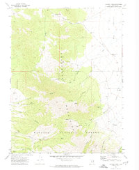
1971 Map of Lookout Pass
USGS Topo · Published 1974About this map
Pony Express Road traverses the northern section of this landscape, marking a vital historical corridor through the high desert of Tooele County. The Site of Lookout Pass Pony Express Station sits at the summit of Lookout Pass, providing a specific anchor for researchers of mid-19th-century mail routes. This 1970s topographic record shows the transition from the Onaqui Mts in the north to the Sheeprock Mountains in the south, much of which is protected within the Wasatch National Forest.
Find a feature on this map
34 named features on this map. Tap any name to fly to it.
Don’t see what you’re looking for? This feature index may not catch every label — zoom into the map to look around manually.
Map Details
Editions of this 1971 Lookout Pass Map
This is the sole edition of this map. No revisions or reprints were ever made.
Other maps of this area

1885 · Sevier Desert
USGS Topo · 1:250,000

1885 · Tooele Valley
USGS Topo · 1:250,000

1953 · Tooele
USGS Topo · 1:250,000

1953 · Delta
USGS Topo · 1:250,000

1955 · Indian Peaks
USGS Topo · 1:24,000

1955 · Indian Springs
USGS Topo · 1:24,000

1955 · Davis Knolls
USGS Topo · 1:24,000

1955 · Tooele
USGS Topo · 1:250,000

1958 · Delta
USGS Topo · 1:250,000

1962 · Delta
USGS Topo · 1:250,000