
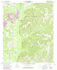
1962 Map of Tabernacle
USGS Topo · Published 1963About this map
Tabernacle and Hebron anchor this 1962 topographical study of Washington County, where the agricultural landscape is defined by the broad wetlands of Buffalo Creek and its many tributaries. The area's industrial character is marked by a large Strip Mine and a Claypit, signaling the local reliance on mineral extraction alongside traditional farming. These extractive sites contrast with the quiet rural network of family-named landmarks and local institutions, such as Swint Spring Ch and Gordy Grove Ch. Transportation in the early sixties relied on the Central Of Georgia railroad and several distinct local routes like Green Lane Road. Genealogists will find significant value in the distribution of family burial grounds, including the Forbes, Moye, and Smith cemeteries, which remain scattered across the drainages of Lamars Creek and Keg Creek.
Find a feature on this map
36 named features on this map. Tap any name to fly to it.
Don’t see what you’re looking for? This feature index may not catch every label — zoom into the map to look around manually.
Map Details
Editions of this 1962 Tabernacle Map
2 editions found
Other maps of this area

1912 · Milledgeville
USGS Topo · 1:62,500

1916 · Irwinton
USGS Topo · 1:62,500

1920 · Irwinton
USGS Topo · 1:62,500

1953 · Athens
USGS Topo · 1:250,000

1957 · Macon
USGS Topo · 1:250,000

1958 · Macon
USGS Topo · 1:250,000

1958 · Athens
USGS Topo · 1:250,000

1959 · Athens
USGS Topo · 1:250,000

1961 · Deepstep
USGS Topo · 1:24,000

1961 · Warthen
USGS Topo · 1:24,000