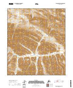
2018 Map of Table Mountain D-4 SW
USGS Topo · Published 2018About this map
The Kongakut River winds through this high-latitude terrain of the North Slope, serving as the primary hydrological feature in an area otherwise defined by its sharp elevation changes and land survey divisions. The map provides a detailed technical view of the Public Land Survey System, specifically demarcating t6s r37e, t7s r37e, t7s r38e, t8s r37e, and t8s r38e. These township and range grids are essential for understanding land partitioning in this part of Alaska, where traditional settlements and roads are absent. The topography is dominated by steep contour intervals that illustrate the complex drainage patterns feeding into the river system, reflecting the landscape as it was documented by the U.S. Geological Survey in the early twenty-first century.
Find a feature on this map
6 named features on this map. Tap any name to fly to it.
Don’t see what you’re looking for? This feature index may not catch every label — zoom into the map to look around manually.
Map Details
Editions of this 2018 Table Mountain D-4 SW Map
This is the sole edition of this map. No revisions or reprints were ever made.
Other maps of this area

1951 · Table Mountain
USGS Topo · 1:250,000

1956 · Table Mountain
USGS Topo · 1:250,000

1964 · Table Mountain
USGS Topo · 1:250,000
1983 · Table Mountain D-4
USGS Topo · 1:63,360
1983 · Table Mountain C-5
USGS Topo · 1:63,360
1983 · Table Mountain D-5
USGS Topo · 1:63,360
1983 · Table Mountain C-4
USGS Topo · 1:63,360
2018 · Table Mountain C-4 NE
USGS Topo · 1:25,000
2018 · Table Mountain D-4 NE
USGS Topo · 1:25,000
2018 · Table Mountain D-4 SE
USGS Topo · 1:25,000