
1969 Map of Table Mountain
USGS Topo · Published 1971About this map
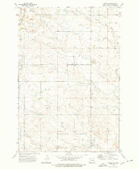
Table Mountain and the surrounding high plains of the Pleasant Valley dominate this late 1960s survey along the border of North and South Dakota. The landscape is defined by its drainages and isolated landforms, including Long Grassy Butte and Dead Horse Butte. The small settlement of Karinen serves as a focal point for local history, featuring the Karinen Sch and several springs. Water management is evident through the naming of numerous draws and creeks such as Sevenmile Creek, Arnett Creek, and Lone Tree Creek. This map illustrates the intersection of Bowman and Harding Counties, capturing the rural infrastructure of the era including a Landing Strip and scattered Drill Hole sites that hint at early resource exploration in this sparsely populated cattle country.
Find a feature on this map
19 named features on this map. Tap any name to fly to it.
Don’t see what you’re looking for? This feature index may not catch every label — zoom into the map to look around manually.
Map Details
Editions of this 1969 Table Mountain Map
This is the sole edition of this map. No revisions or reprints were ever made.
Other maps of this area

1935 · Buffalo
USGS Topo · 1:125,000

1953 · Dickinson
USGS Topo · 1:250,000

1954 · Lemmon
USGS Topo · 1:250,000

1957 · Dickinson
USGS Topo · 1:250,000

1957 · Lemmon
USGS Topo · 1:250,000

1969 · Ladner NE
USGS Topo · 1:24,000

1969 · Ladner
USGS Topo · 1:24,000

1969 · Ladner SE
USGS Topo · 1:24,000

1973 · Camel Butte
USGS Topo · 1:24,000
1973 · Rhame SE
USGS Topo · 1:24,000