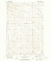
1973 Map of Rhame SE
USGS Topo · Published 1977About this map
North Fork Grand River drainage systems define this section of Bowman County, where the topography transition from the Adelaide Hills in the northwest to the wide valleys of the south. This 1973 field survey documents a landscape dominated by ranching and resource extraction, punctuated by the seasonal flows of Alkali Creek and the curiously named Cold Turkey Creek. Land use patterns are clearly delineated through township boundaries like Amor and Grand River, while the presence of an Oil Well and several Gravel Pits indicate the area's mid-century industrial interests. The map serves as a precise record of rural development, showing the network of section-line roads and scattered dwellings that serviced this portion of the Dakota plains.
Find a feature on this map
10 named features on this map. Tap any name to fly to it.
Don’t see what you’re looking for? This feature index may not catch every label — zoom into the map to look around manually.
Map Details
Editions of this 1973 Rhame SE Map
This is the sole edition of this map. No revisions or reprints were ever made.
Other maps of this area

1935 · Reva
USGS Topo · 1:125,000

1935 · Buffalo
USGS Topo · 1:125,000

1953 · Dickinson
USGS Topo · 1:250,000

1954 · Lemmon
USGS Topo · 1:250,000

1957 · Dickinson
USGS Topo · 1:250,000

1957 · Lemmon
USGS Topo · 1:250,000

1968 · Bowman SW
USGS Topo · 1:24,000

1968 · Bowman
USGS Topo · 1:24,000

1968 · Eagles Nest Butte
USGS Topo · 1:24,000

1969 · Ladner NE
USGS Topo · 1:24,000