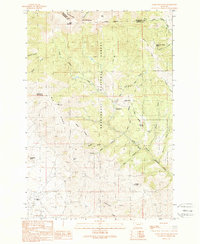
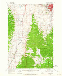
1989 Map of Table Mountain
USGS Topo · Published 1989About this map
The Highland Mountains dominate this 1989 survey, marked by high peaks such as Table Mountain and East Peak. The area is characterized by a landscape of steep gulches and canyons, where the Beaverhead National Forest boundary meets the county line between Silver Bow and Madison counties. Remote outposts like the Hells Canyon FS Station indicate the administrative presence in these high woods during the late 20th century.
Find a feature on this map
40 named features on this map. Tap any name to fly to it.
Don’t see what you’re looking for? This feature index may not catch every label — zoom into the map to look around manually.
Map Details
Editions of this 1989 Table Mountain Map
This is the sole edition of this map. No revisions or reprints were ever made.
Other maps of this area

1893 · Dillon
USGS Topo · 1:250,000

1955 · Dillon
USGS Topo · 1:250,000

1957 · Dillon
USGS Topo · 1:250,000

1958 · Dillon
USGS Topo · 1:250,000
1960 · Twin Bridges
USGS Topo · 1:62,500
1961 · Wickiup Creek
USGS Topo · 1:24,000
1961 · Nez Perce Hollow
USGS Topo · 1:24,000
1961 · Butte South
USGS Topo · 1:62,500

1962 · Dillon
USGS Topo · 1:250,000
1963 · Pipestone Pass
USGS Topo · 1:24,000