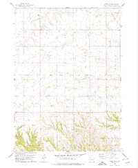
1978 Map of Tabor NE
USGS Topo · Published 1979About this map
Yankton County farmland and drainages are surveyed here in the late 1970s, revealing a landscape defined by small agrarian communities and family heritage. The rural character of the region is punctuated by numerous burial grounds including Polish Cem, Nikodym Cem, and Nedved Cem, which provide significant anchor points for genealogical research. The settlement of Utica sits at the northeastern edge of the map, served by the Chicago Milwaukee St Paul and Pacific railroad line that cuts horizontally across the central terrain.
Find a feature on this map
14 named features on this map. Tap any name to fly to it.
Don’t see what you’re looking for? This feature index may not catch every label — zoom into the map to look around manually.
Map Details
Editions of this 1978 Tabor NE Map
This is the sole edition of this map. No revisions or reprints were ever made.
Other maps of this area

1898 · Olivet
USGS Topo · 1:125,000

1898 · Parker
USGS Topo · 1:125,000

1955 · Sioux City
USGS Topo · 1:250,000

1955 · Sioux Falls
USGS Topo · 1:250,000

1957 · Jamesville
USGS Topo · 1:24,000

1958 · Sioux City
USGS Topo · 1:250,000

1958 · Sioux Falls
USGS Topo · 1:250,000

1959 · Sioux City
USGS Topo · 1:250,000

1968 · Tabor SE
USGS Topo · 1:24,000

1968 · Gavins Point Dam
USGS Topo · 1:24,000
Featured Places
- Utica, SD
- Ziskov North Township, SD
- Central Township, SD
- Lesterville Township, SD
- Utica South Township, SD