
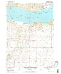
1968 Map of Tabor SE
USGS Topo · Published 1970About this map
Lewis and Clark Lake dominates this 1960s landscape, marking the dammed Missouri River on the border of Nebraska and South Dakota. The creation of this reservoir transformed the local topography, establishing a hub for regional recreation that includes the Lewis and Clark Lake State Park, Lesterville Recreation Area, and several specific zones like the Deep Water Recreation Area. South of the shoreline, the rural character of Knox County is defined by organized townships including Frankfort and Eastern.
Find a feature on this map
26 named features on this map. Tap any name to fly to it.
Don’t see what you’re looking for? This feature index may not catch every label — zoom into the map to look around manually.
Map Details
Editions of this 1968 Tabor SE Map
2 editions found
Other maps of this area

1955 · Sioux City
USGS Topo · 1:250,000

1958 · Sioux City
USGS Topo · 1:250,000

1959 · Sioux City
USGS Topo · 1:250,000

1968 · Bloomfield NE
USGS Topo · 1:24,000

1968 · Gavins Point Dam
USGS Topo · 1:24,000

1968 · Crofton
USGS Topo · 1:24,000

1974 · Lindy
USGS Topo · 1:24,000

1974 · Bon Homme Colony
USGS Topo · 1:24,000
1977 · Lindy
USGS Topo · 1:24,000
1978 · Tabor NE
USGS Topo · 1:24,000
Featured Places
- Northshore Development, SD
- Oak Hills Addition, SD
- Fairview Heights, SD
- Utica South Township, SD
- North Frankfort Township, NE