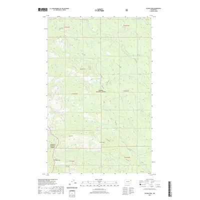
2020 Map of Tacoma Peak
USGS Topo · Published 2020About this map
The Kaniksu National Forest and Colville National Forest dominate this high-country landscape in Pend Oreille County. The terrain is defined by a series of prominent summits, including Tacoma Peak, Calispell Peak, and the distinctively named Dirty Shirt. These peaks form a complex drainage system where the Tacoma Cr network, including its North and South Forks, carves through the timbered slopes. Evidence of backcountry access is visible through the Batey Bould route and the Batey Bould Loop, which navigate the steep elevations between Boulder Mtn and Little Calispell Peak. In the southern reaches, the topography softens slightly near Conger Lake and Conger Pond, where Trimble Cr and E Fork Small Cr begin their descent. The map illustrates a contemporary wilderness managed for conservation and recreation, preserved in its modern state.
Find a feature on this map
26 named features on this map. Tap any name to fly to it.
Don’t see what you’re looking for? This feature index may not catch every label — zoom into the map to look around manually.
Map Details
Editions of this 2020 Tacoma Peak Map
This is the sole edition of this map. No revisions or reprints were ever made.
Other maps of this area

1927 · Chewelah
USGS Topo · 1:125,000

1929 · Colville
USGS Topo · 1:125,000

1930 · Chewelah
USGS Topo · 1:125,000

1933 · Colville
USGS Topo · 1:125,000

1934 · Metaline
USGS Topo · 1:125,000

1936 · Newport
USGS Topo · 1:96,000

1942 · Metaline
USGS Topo · 1:125,000

1942 · Newport
USGS Topo · 1:125,000

1958 · Sandpoint
USGS Topo · 1:250,000

1963 · Sandpoint
USGS Topo · 1:250,000