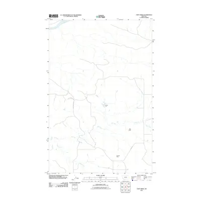
2011 Map of Taffy Ridge
USGS Topo · Published 2011About this map
The Missouri River cuts through the northern reaches of this landscape, anchoring a network of intermittent waterways and elevated breaks in Fergus County. The terrain is defined by prominent landforms such as Taffy Ridge and Cutbank Ridge, which overlook a drainage system including Taffy Creek, the N Fork Taffy Cr, and Cutbank Creek. Human presence is sparse, marked primarily by a few localized infrastructure features such as Chicken Dam and a handful of rural transit routes. Stafford Ferry Rd and Kjorlien Rd provide the primary access through this area, reflecting a remote ranching or agricultural character. The map illustrates how the land is segmented by deep-cut coulees and ridges, with Dog Creek winding through the western portion of the quadrangle.
Find a feature on this map
10 named features on this map. Tap any name to fly to it.
Don’t see what you’re looking for? This feature index may not catch every label — zoom into the map to look around manually.
Map Details
Editions of this 2011 Taffy Ridge Map
This is the sole edition of this map. No revisions or reprints were ever made.
Other maps of this area

1954 · Taffy Ridge
USGS Topo · 1:24,000

1954 · Bird Rapids
USGS Topo · 1:24,000

1954 · Leroy
USGS Topo · 1:24,000

1954 · Gallatin Rapids
USGS Topo · 1:24,000

1954 · Lewistown
USGS Topo · 1:250,000

1959 · Lewistown
USGS Topo · 1:250,000

1964 · Ragland Bench
USGS Topo · 1:24,000

1985 · Woodhawk Hill
USGS Topo · 1:24,000
1985 · Gerhard Corner
USGS Topo · 1:24,000
1985 · Winifred East
USGS Topo · 1:24,000