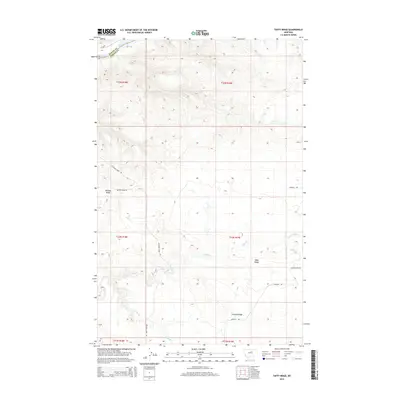
2014 Map of Taffy Ridge
USGS Topo · Published 2014About this map
The Missouri River forms a significant boundary in this corner of Montana, separating Blaine and Fergus counties. This landscape is defined by its dramatic topographic relief, where the river has carved deep through the high plains. Navigation and crossing points are central to the area's history, marked here by Bird Rapids and the route of Stafford Ferry Rd. Moving away from the water, the terrain rises into prominent plateaus including Whiskey Ridge, Taffy Ridge, and Cutbank Ridge. This 2014 survey documents a sparsely populated ranching landscape, where the primary human footprint consists of a limited network of gravel roads such as Whiskey Ridge Rd and Blackwelder Rd. Smaller seasonal drainage systems like Taffy Cr and Cutbank Cr intersect the ridges, creating a complex network of coulees and draws typical of the Missouri River Breaks region.
Find a feature on this map
19 named features on this map. Tap any name to fly to it.
Don’t see what you’re looking for? This feature index may not catch every label — zoom into the map to look around manually.
Map Details
Editions of this 2014 Taffy Ridge Map
This is the sole edition of this map. No revisions or reprints were ever made.
Other maps of this area

1954 · Taffy Ridge
USGS Topo · 1:24,000

1954 · Bird Rapids
USGS Topo · 1:24,000

1954 · Leroy
USGS Topo · 1:24,000

1954 · Gallatin Rapids
USGS Topo · 1:24,000

1954 · Lewistown
USGS Topo · 1:250,000

1959 · Lewistown
USGS Topo · 1:250,000

1964 · Ragland Bench
USGS Topo · 1:24,000

1985 · Woodhawk Hill
USGS Topo · 1:24,000
1985 · Gerhard Corner
USGS Topo · 1:24,000
1985 · Winifred East
USGS Topo · 1:24,000