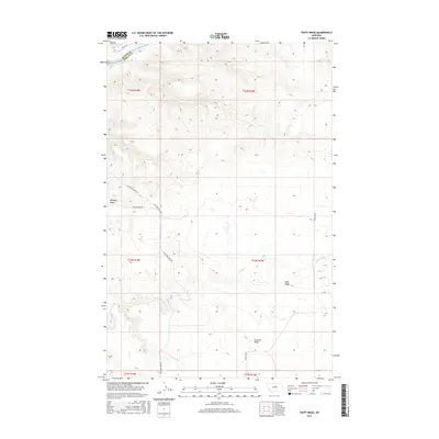
2017 Map of Taffy Ridge
USGS Topo · Published 2017About this map
The Missouri River cuts through the northern reaches of this territory, where the turbulent Dauphin Rapids provide a natural navigational landmark on the border of Blaine and Fergus counties. The landscape is defined by a series of prominent high points, including Whiskey Ridge in the west and the central Taffy Ridge, which separates the drainages of Taffy Cr and Cutbank Cr. A sparse network of rural roads, such as Stafford Ferry Rd and Kjorlien Rd, provides access to the high plateaus and creek bottoms. This 2017 survey reflects the enduring character of this Montana ranching country, showing the relationship between the elevated ridges and the water sources that have sustained the region's land use patterns for generations.
Find a feature on this map
20 named features on this map. Tap any name to fly to it.
Don’t see what you’re looking for? This feature index may not catch every label — zoom into the map to look around manually.
Map Details
Editions of this 2017 Taffy Ridge Map
This is the sole edition of this map. No revisions or reprints were ever made.
Other maps of this area

1954 · Taffy Ridge
USGS Topo · 1:24,000

1954 · Bird Rapids
USGS Topo · 1:24,000

1954 · Leroy
USGS Topo · 1:24,000

1954 · Gallatin Rapids
USGS Topo · 1:24,000

1954 · Lewistown
USGS Topo · 1:250,000

1959 · Lewistown
USGS Topo · 1:250,000

1964 · Ragland Bench
USGS Topo · 1:24,000

1985 · Woodhawk Hill
USGS Topo · 1:24,000
1985 · Gerhard Corner
USGS Topo · 1:24,000
1985 · Winifred East
USGS Topo · 1:24,000