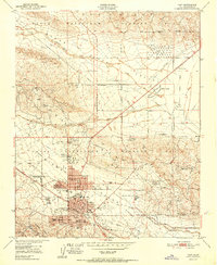
1951 Map of Taft
USGS Topo · Published 1951About this map
The industrial landscape of the Kern County oil fields is meticulously documented in this 1951 survey, dominated by the massive acreage of Naval Petroleum Reserve No 1 and Naval Petroleum Reserve No 2. The city of Taft serves as the central hub for this energy-rich corridor, surrounded by residential districts like Taft Heights and South Taft. This map offers a rare look at the specialized company settlements of the era, including numerous Standard Oil camps and the Honolulu Oil Main Camp, which housed workers and their families directly within the fields. Beyond the oil infrastructure, local life is visible through institutions like the Taft Union HS and JC, Jefferson School, and the social Petroleum Club. The topography transitions from the active drilling sites on Spellacy Hill and the Buena Vista Hills down into the Buena Vista Valley, illustrating how the boom-town geography was dictated by the underlying geology.
Find a feature on this map
42 named features on this map. Tap any name to fly to it.
Don’t see what you’re looking for? This feature index may not catch every label — zoom into the map to look around manually.
Map Details
Editions of this 1951 Taft Map
This is the sole edition of this map. No revisions or reprints were ever made.
Other maps of this area

1910 · Buena Vista Lake
USGS Topo · 1:125,000

1912 · McKittrick
USGS Topo · 1:125,000

1912 · Buena Vista Lake
USGS Topo · 1:125,000

1929 · Coles Levee
USGS Topo · 1:31,680

1929 · Mouth of Kern
USGS Topo · 1:31,680

1931 · Pentland Junction
USGS Topo · 1:31,680

1932 · West Elk Hills
USGS Topo · 1:31,680

1932 · East Elk Hills
USGS Topo · 1:31,680

1932 · Mouth of Kern
USGS Topo · 1:31,680
1933 · Tupman
USGS Topo · 1:31,680