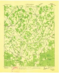
1936 Map of Taft
USGS Topo · Published 1936About this map
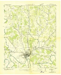
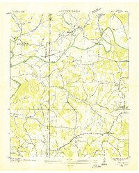
Elk River winds through the northwestern corner of this Lincoln County survey, while a dense network of hollows such as Stillhouse Hollow and Hutchinson Hollow shapes the rural landscape. In 1936, the Tennessee Valley Authority and U.S. Geological Survey mapped this area as it transitioned into the modern electrical age, evidenced by the prominent Electric Transmission Line cutting across the terrain. Small rural hubs like Taft and Coldwater serve as anchors for the surrounding agricultural community, where social life centered on institutions like Smith Chapel and local schoolhouses including Mary Grove Sch. The map reveals a highly localized economy and geography, noting specific family-named landmarks like Bryant Cem and functional sites such as the County Farm Road. Low-lying areas in the southeast are dominated by the Whiteoak Swamp and Locke Swamp, showing the natural drainage patterns of the region before significant modern development.
Find a feature on this map
47 named features on this map. Tap any name to fly to it.
Don’t see what you’re looking for? This feature index may not catch every label — zoom into the map to look around manually.
Map Details
Editions of this 1936 Taft Map
This is the sole edition of this map. No revisions or reprints were ever made.
Other maps of this area

1888 · Huntsville
USGS Topo · 1:125,000

1892 · Huntsville
USGS Topo · 1:125,000

1936 · Fisk
USGS Topo · 1:24,000
1936 · Boonshill
USGS Topo · 1:24,000
1936 · Ardmore
USGS Topo · 1:24,000

1936 · Lincoln
USGS Topo · 1:24,000

1936 · Toney
USGS Topo · 1:24,000
1936 · Frankewing
USGS Topo · 1:24,000
1936 · Fayetteville
USGS Topo · 1:24,000
1936 · Dellrose
USGS Topo · 1:24,000