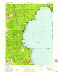
1955 Map of Tahoe
USGS Topo · Published 1958About this map
Tahoe City and the northwestern shores of Lake Tahoe are captured here in the mid-1950s, showing a landscape defined by seasonal recreation and lakeside settlements before the massive expansion of the modern era. The map traces the rugged Western Shore through communities like Homewood, Tahoe Pines, and Sunnyside, where the influence of early lodge-based tourism is evident at Chambers Lodge and the historic Tahoe Tavern. Further north, Kings Beach and Brockway mark the transition toward the Nevada border at Stateline Point.
Find a feature on this map
103 named features on this map. Tap any name to fly to it.
Don’t see what you’re looking for? This feature index may not catch every label — zoom into the map to look around manually.
Map Details
Editions of this 1955 Tahoe Map
3 editions found
Other maps of this area

1889 · Pyramid Peak
USGS Topo · 1:125,000

1889 · Markleeville
USGS Topo · 1:125,000

1891 · Carson
USGS Topo · 1:125,000

1891 · Markleeville
USGS Topo · 1:125,000

1891 · Truckee
USGS Topo · 1:125,000

1891 · Pyramid Peak
USGS Topo · 1:125,000

1893 · Carson
USGS Topo · 1:125,000

1893 · Markleeville
USGS Topo · 1:125,000

1893 · Truckee
USGS Topo · 1:125,000

1895 · Pyramid Peak
USGS Topo · 1:125,000