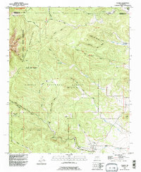
1990 Map of Tajique
USGS Topo · Published 1996About this map
Tajique sits at the eastern foot of the Manzano Mountains, where the high desert meets the wooded slopes of the Cibola National Forest. This mapping reflects a complex landscape of historical land grants and modern recreation, showing the boundaries of the Pueblo de Isleta Grant, the Chilili Grant, and the Tajique Grant. The settlement pattern follows the drainage of the Arroyo de Tajique, with several family-named locations such as Riley Place and Glover Place dotting the canyon floors.
Find a feature on this map
41 named features on this map. Tap any name to fly to it.
Don’t see what you’re looking for? This feature index may not catch every label — zoom into the map to look around manually.
Map Details
Editions of this 1990 Tajique Map
This is the sole edition of this map. No revisions or reprints were ever made.
Other maps of this area

1917 · Estancia
USGS Topo · 1:125,000

1954 · Bosque Peak
USGS Topo · 1:24,000

1954 · Chilili
USGS Topo · 1:24,000

1954 · Capilla Peak
USGS Topo · 1:24,000

1954 · Mount Washington
USGS Topo · 1:24,000

1954 · Torreon
USGS Topo · 1:24,000

1954 · Tajique
USGS Topo · 1:24,000

1954 · Escabosa
USGS Topo · 1:24,000

1954 · Milbourn Ranch
USGS Topo · 1:24,000

1954 · Torreon
USGS Topo · 1:62,500