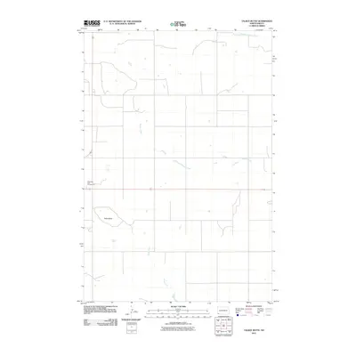
2011 Map of Talbot Butte
USGS Topo · Published 2011About this map
Talbot Butte rises as a prominent landmark in this section of Bowman County, characterizing the high plains landscape of southwestern North Dakota. This 2011 survey documents a sparsely populated rural area where the grid of section lines and local roads is interrupted by the meandering paths of South Fork Cedar Creek and Buffalo Creek. The intersection of two major transportation routes, Highway 85 and Highway 12, provides the primary access to the region. Public land use is represented by the Butte View State Campground, positioned near the western edge of the quadrangle. The map captures a landscape defined by ranching and open space, where drainage systems like Stage Creek serve as the primary natural breaks in an otherwise strictly organized agricultural grid.
Find a feature on this map
7 named features on this map. Tap any name to fly to it.
Don’t see what you’re looking for? This feature index may not catch every label — zoom into the map to look around manually.
Map Details
Editions of this 2011 Talbot Butte Map
This is the sole edition of this map. No revisions or reprints were ever made.
Other maps of this area

1953 · Dickinson
USGS Topo · 1:250,000

1957 · Dickinson
USGS Topo · 1:250,000

1968 · Bowman SW
USGS Topo · 1:24,000

1968 · Bowman
USGS Topo · 1:24,000

1969 · Scranton
USGS Topo · 1:24,000

1973 · Mineral Springs
USGS Topo · 1:24,000

1973 · Talbot Butte
USGS Topo · 1:24,000

1973 · Amidon SE
USGS Topo · 1:24,000
1973 · Scranton SW
USGS Topo · 1:24,000
1973 · Bowman SE
USGS Topo · 1:24,000