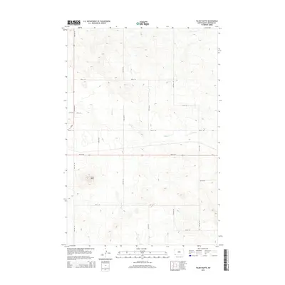
2014 Map of Talbot Butte
USGS Topo · Published 2014About this map
Talbot Butte rises as a prominent landmark in this prairie landscape, serving as a focal point for the surrounding drainages of S Fork Cedar Cr and Buffalo Cr. The terrain is defined by a systematic grid of section roads and rural routes, including 83rd St SW and 88th St SW, which illustrate the persistent land-use patterns of Bowman County. Drainage systems like Stage Cr cut through the undulating plains, highlighting the natural watercourses that have historically dictated ranching and settlement boundaries in this corner of North Dakota. The proximity of Us-85 and State Route 12 indicates the primary corridors of travel and transport that connect this remote rangeland to the broader region.
Find a feature on this map
22 named features on this map. Tap any name to fly to it.
Don’t see what you’re looking for? This feature index may not catch every label — zoom into the map to look around manually.
Map Details
Editions of this 2014 Talbot Butte Map
This is the sole edition of this map. No revisions or reprints were ever made.
Other maps of this area

1953 · Dickinson
USGS Topo · 1:250,000

1957 · Dickinson
USGS Topo · 1:250,000

1968 · Bowman SW
USGS Topo · 1:24,000

1968 · Bowman
USGS Topo · 1:24,000

1969 · Scranton
USGS Topo · 1:24,000

1973 · Mineral Springs
USGS Topo · 1:24,000

1973 · Talbot Butte
USGS Topo · 1:24,000

1973 · Amidon SE
USGS Topo · 1:24,000
1973 · Scranton SW
USGS Topo · 1:24,000
1973 · Bowman SE
USGS Topo · 1:24,000