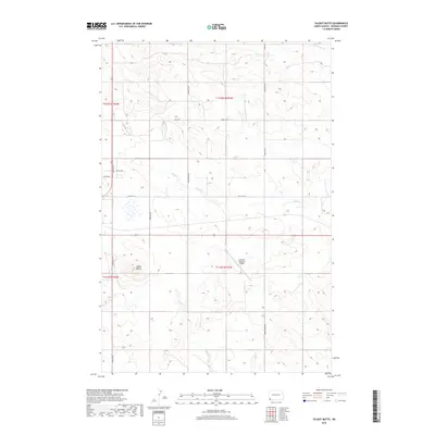
2018 Map of Talbot Butte
USGS Topo · Published 2018About this map
Talbot Butte rises above the open range of western North Dakota, serving as a prominent landmark in this corner of Bowman County. The landscape is defined by the ephemeral drainage patterns of Buffalo Creek and Slough Creek, which wind through the prairie terrain. Human impact is centered on the Bowman Regional Airport, a modern node of transportation located near the section lines of T131N R101W. A grid of section roads including Gene Hansey Road and Don Hagal Road crisscrosses the township, reflecting the orderly land division of the Great Plains. To the north, the headwaters of the South Fork Cedar Creek cut through the undulating hills, illustrating the subtle but persistent watershed of the high plains during this contemporary period.
Find a feature on this map
20 named features on this map. Tap any name to fly to it.
Don’t see what you’re looking for? This feature index may not catch every label — zoom into the map to look around manually.
Map Details
Editions of this 2018 Talbot Butte Map
This is the sole edition of this map. No revisions or reprints were ever made.
Other maps of this area

1953 · Dickinson
USGS Topo · 1:250,000

1957 · Dickinson
USGS Topo · 1:250,000

1968 · Bowman SW
USGS Topo · 1:24,000

1968 · Bowman
USGS Topo · 1:24,000

1969 · Scranton
USGS Topo · 1:24,000

1973 · Mineral Springs
USGS Topo · 1:24,000

1973 · Talbot Butte
USGS Topo · 1:24,000

1973 · Amidon SE
USGS Topo · 1:24,000
1973 · Scranton SW
USGS Topo · 1:24,000
1973 · Bowman SE
USGS Topo · 1:24,000