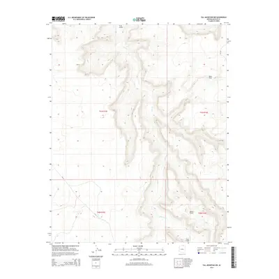
2014 Map of Tall Mountain NW
USGS Topo · Published 2014About this map
Piute Canyon dominates this portion of the Navajo Nation, revealing a landscape defined by dramatic elevation changes and remote plateau systems. The intermittent flow of Piute Creek carves through the central terrain, separating the high expanse of Piute Mesa in the northeast from the Shonto Plateau to the south. This 2014 survey illustrates the sparse infrastructure typical of this high-desert environment, where transportation is limited to established routes like Bia-16 and Bia-6310. The map provides a clear look at the township and range boundaries, including t41n r15e and t40n r16e, which anchor this rugged section of Navajo County. For those studying the geography of Northern Arizona, the map offers an exact record of the drainage patterns and landform orientations that dictate movement across this territory.
Find a feature on this map
11 named features on this map. Tap any name to fly to it.
Don’t see what you’re looking for? This feature index may not catch every label — zoom into the map to look around manually.
Map Details
Editions of this 2014 Tall Mountain NW Map
This is the sole edition of this map. No revisions or reprints were ever made.
Other maps of this area

1883 · Marsh Pass
USGS Topo · 1:250,000

1886 · Henry Mountains
USGS Topo · 1:250,000

1892 · Marsh Pass
USGS Topo · 1:250,000

1892 · Henry Mountains
USGS Topo · 1:250,000
1952 · Shato Spring 1 NE
USGS Topo · 1:24,000
1952 · Navajo Mtn. 4 SE
USGS Topo · 1:24,000
1953 · Navajo Mountain 4 SW
USGS Topo · 1:24,000
1953 · Navajo Mountain
USGS Topo · 1:62,500
1953 · No Mans Mesa
USGS Topo · 1:62,500
1956 · Escalante
USGS Topo · 1:250,000