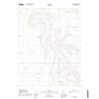
2018 Map of Tall Mountain NW
USGS Topo · Published 2018About this map
Piute Canyon carves a deep path through this corner of Navajo County, defining a landscape of high desert mesas and deep drainage systems. The Piute Cr flows through the heart of the canyon, flanked by the elevated reaches of Piute Mesa to the northeast and the rising edge of the Shonto Plateau to the south. This remote terrain is navigated by a single primary roadway, N Rte 16, which crosses the southwestern sections. The map provides a detailed view of the complex topography typical of the Navajo Nation, illustrating the intricate network of ridgelines and ravines that dictate the movement of both water and travel across this part of northern Arizona.
Find a feature on this map
9 named features on this map. Tap any name to fly to it.
Don’t see what you’re looking for? This feature index may not catch every label — zoom into the map to look around manually.
Map Details
Editions of this 2018 Tall Mountain NW Map
This is the sole edition of this map. No revisions or reprints were ever made.
Other maps of this area

1883 · Marsh Pass
USGS Topo · 1:250,000

1886 · Henry Mountains
USGS Topo · 1:250,000

1892 · Marsh Pass
USGS Topo · 1:250,000

1892 · Henry Mountains
USGS Topo · 1:250,000
1952 · Shato Spring 1 NE
USGS Topo · 1:24,000
1952 · Navajo Mtn. 4 SE
USGS Topo · 1:24,000
1953 · Navajo Mountain 4 SW
USGS Topo · 1:24,000
1953 · Navajo Mountain
USGS Topo · 1:62,500
1953 · No Mans Mesa
USGS Topo · 1:62,500
1956 · Escalante
USGS Topo · 1:250,000