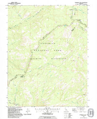
1992 Map of Tamarack Flat
USGS Topo · Published 1995About this map
The Middle Fork Tuolumne River and South Fork Tuolumne River dominate the high-elevation drainage patterns of this Sierra Nevada landscape. Managed largely within Yosemite National Park and the protected Yosemite Wilderness, the area showcases a wilderness character defined by steep topographic relief and seasonal watercourses. The iconic Tioga Road snakes across the terrain, providing access to remote locations like White Wolf Campground and McSwain Meadows.
Find a feature on this map
19 named features on this map. Tap any name to fly to it.
Don’t see what you’re looking for? This feature index may not catch every label — zoom into the map to look around manually.
Map Details
Editions of this 1992 Tamarack Flat Map
This is the sole edition of this map. No revisions or reprints were ever made.
Other maps of this area

1897 · Yosemite
USGS Topo · 1:125,000

1900 · Yosemite
USGS Topo · 1:125,000

1903 · Yosemite
USGS Topo · 1:125,000

1909 · Yosemite
USGS Topo · 1:125,000

1947 · El Portal
USGS Topo · 1:24,000

1947 · Mariposa
USGS Topo · 1:250,000

1947 · El Portal
USGS Topo · 1:62,500

1948 · Mariposa
USGS Topo · 1:250,000
1949 · El Portal
USGS Topo · 1:24,000

1956 · Hetch Hetchy Reservoir
USGS Topo · 1:62,500