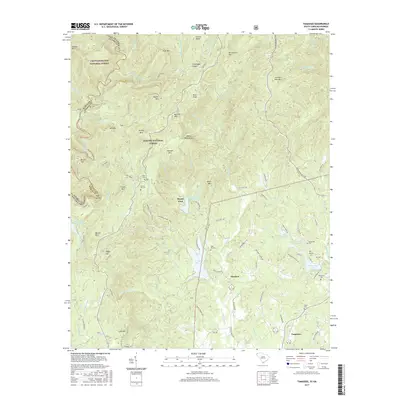
2017 Map of Tamassee
USGS Topo · Published 2017About this map
Tamassee and Cheohee anchor the southern reaches of this Appalachian landscape, where the Blue Ridge Escarpment meets the Piedmont. The terrain is defined by the Chattooga Ridge and a series of high points like Persimmon Mtn and Burrells Mtn. Waterways are central to the geography, from the wild Chattooga River forming the state boundary to the man-made Lake Cherokee and Lake Cheohee. Local history is preserved in a high density of family and community burial grounds, including Winchester Cem, Cherry Hill Cem, and the Wolf Pit Cem. The map reveals a land heavily managed for conservation, with significant acreage dedicated to the Sumter National Forest and the Chattahoochee National Forest. Historic transportation routes like the Winding Stairs Trail and Chattooga Hiking Trail highlight the transition from settler-era paths to modern recreational corridors.
Find a feature on this map
102 named features on this map. Tap any name to fly to it.
Don’t see what you’re looking for? This feature index may not catch every label — zoom into the map to look around manually.
Map Details
Editions of this 2017 Tamassee Map
This is the sole edition of this map. No revisions or reprints were ever made.
Other maps of this area

1886 · Walhalla
USGS Topo · 1:125,000

1888 · Pickens
USGS Topo · 1:125,000

1891 · Cowee
USGS Topo · 1:125,000

1892 · Walhalla
USGS Topo · 1:125,000

1894 · Pickens
USGS Topo · 1:125,000

1896 · Walhalla
USGS Topo · 1:125,000

1897 · Cowee
USGS Topo · 1:125,000

1905 · Pisgah
USGS Topo · 1:125,000

1906 · Pisgah
USGS Topo · 1:125,000

1907 · Cowee
USGS Topo · 1:125,000