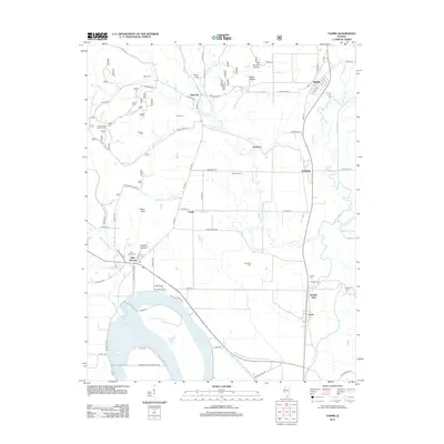
2012 Map of Tamms
USGS Topo · Published 2012About this map
Horseshoe Lake dominates the southern landscape of this 2012 study, surrounded by the Horseshoe Lake Consrv Area. This region of southern Illinois is defined by a dense network of meandering waterways, including the Cache River, Sandy Cr, and Hogskin Cr, which weave through low-lying areas and hollows like Beech Hollow and Coakley Hollow. Settlement patterns follow the higher ground and road networks, with the community of Tamms in the northeast and smaller hubs such as Olive Branch, Sandusky, and Diswood scattered throughout. The map is a valuable resource for genealogists, documenting numerous family and community burial grounds including Miller Cem, McCrite Cem, and Solomon Cem. Evidence of local infrastructure includes the Honey School Lookout Tower and the railroad siding at Davey Switch, reflecting the intersection of conservation, agriculture, and transit in the early 21st century.
Find a feature on this map
85 named features on this map. Tap any name to fly to it.
Don’t see what you’re looking for? This feature index may not catch every label — zoom into the map to look around manually.
Map Details
Editions of this 2012 Tamms Map
This is the sole edition of this map. No revisions or reprints were ever made.
Other maps of this area

1920 · Jonesboro
USGS Topo · 1:62,500

1920 · Dongola
USGS Topo · 1:62,500

1923 · Dongola
USGS Topo · 1:62,500

1923 · Jonesboro
USGS Topo · 1:62,500

1931 · Cairo
USGS Topo · 1:62,500

1933 · Cairo
USGS Topo · 1:62,500

1934 · Thebes
USGS Topo · 1:62,500

1939 · Cairo
USGS Topo · 1:62,500

1939 · Thebes
USGS Topo · 1:62,500

1947 · Jonesboro
USGS Topo · 1:62,500