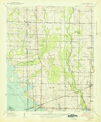
1938 Map of Tanner
USGS Topo · Published 1938About this map
The Wheeler Reservoir defines the southwestern edge of this 1938 survey, illustrating the transformation of the Tennessee River valley during the early Tennessee Valley Authority era. The landscape is a transition from the river bottomlands at Hantie Bottoms to the established agricultural communities inland. The Bee Line Highway runs north-to-south, serving as a primary corridor through Tanner and past Stewarts Store. In the southeast, the historic layout of Mooresville and nearby Belle Mina is visible, including the Mooresville and Belle Mina Sch. Numerous family-named landmarks such as the Anderson Plantation and Murphree Place are documented, along with community focal points like Nazareth Ch and New Zion Ch. The presence of the Louisville and Nashville and Southern railroads highlights the vital transportation network supporting the region's rural economy.
Find a feature on this map
48 named features on this map. Tap any name to fly to it.
Don’t see what you’re looking for? This feature index may not catch every label — zoom into the map to look around manually.
Map Details
Editions of this 1938 Tanner Map
This is the sole edition of this map. No revisions or reprints were ever made.
Other maps of this area

1888 · Huntsville
USGS Topo · 1:125,000

1892 · Huntsville
USGS Topo · 1:125,000

1935 · Athens
USGS Topo · 1:24,000

1936 · Capshaw
USGS Topo · 1:24,000

1936 · Decatur
USGS Topo · 1:24,000

1936 · Stewart Cross Roads
USGS Topo · 1:24,000

1936 · Ripley
USGS Topo · 1:24,000

1936 · Trinity
USGS Topo · 1:24,000

1936 · Mason Ridge
USGS Topo · 1:24,000

1936 · Tanner
USGS Topo · 1:24,000