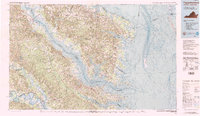
1984 Map of Tappahannock
USGS Topo · Published 1984About this map
The Rappahannock River serves as the central artery for this 1984 survey, carving through the Northern Neck and Middle Peninsula of Virginia toward the Chesapeake Bay. Major regional hubs like Tappahannock and Warsaw anchor the upper reaches, while the river mouth opens wide past Stingray Point and Windmill Point. The map provides a high-resolution view of the intricate coastline, detailing the numerous inlets of the Potomac River including the Yeocomico River and Coan River. This transition from freshwater systems to the saltier waters of Tangier Sound illustrates the maritime character of communities like Reedville and Deltaville. Farther inland, the confluence of the Mattaponi River and Pamunkey River at West Point defines the birth of the York River, highlighting the region's historic dependence on these waterways for transport and trade.
Find a feature on this map
116 named features on this map. Tap any name to fly to it.
Don’t see what you’re looking for? This feature index may not catch every label — zoom into the map to look around manually.
Map Details
Editions of this 1984 Tappahannock Map
3 editions found
Other maps of this area

1889 · Fredericksburg
USGS Topo · 1:125,000

1892 · Fredericksburg
USGS Topo · 1:125,000

1892 · Piney Point
USGS Topo · 1:62,500

1892 · Montross
USGS Topo · 1:62,500

1894 · Fredericksburg
USGS Topo · 1:125,000

1894 · Piney Point
USGS Topo · 1:62,500

1894 · Point Lookout
USGS Topo · 1:62,500

1895 · Nomini
USGS Topo · 1:125,000

1895 · Piney Point
USGS Topo · 1:62,500

1895 · Montross
USGS Topo · 1:62,500