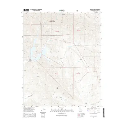
2015 Map of Tar Spring Ridge
USGS Topo · Published 2015About this map
Los Padres National Forest encompasses the northern portion of this landscape, where the Santa Lucia Range meets the upper reaches of the Arroyo Grande Valley. The terrain is defined by a series of prominent ridges and drainages, most notably Tar Spring Ridge and Saucelito Ridge. Central to the geography is Lopez Lake, a reservoir fed by Arroyo Grande Cr and Lopez Canyon. This modern survey illustrates the intricate network of fire roads and trails necessary for forest management, including Hi Mountain Rd and the Cougar Trail. Local history is reflected in the naming of diverse canyons and flats, such as Clapboard Canyon and Washington Flat. The map also captures the transition from public forest lands to the agricultural and ranching areas along Huasna Rd and Santa Manuela Rd in the south.
Find a feature on this map
35 named features on this map. Tap any name to fly to it.
Don’t see what you’re looking for? This feature index may not catch every label — zoom into the map to look around manually.
Map Details
Editions of this 2015 Tar Spring Ridge Map
This is the sole edition of this map. No revisions or reprints were ever made.
Other maps of this area
1897 · San Luis Obispo
USGS Topo · 1:62,500
1897 · Arroyo Grande
USGS Topo · 1:62,500
1900 · San Luis
USGS Topo · 1:125,000
1922 · Pozo
USGS Topo · 1:62,500
1922 · Nipomo
USGS Topo · 1:62,500
1942 · San Luis Obispo
USGS Topo · 1:62,500
1942 · Arroyo Grande
USGS Topo · 1:62,500
1947 · San Luis Obispo
USGS Topo · 1:250,000
1948 · San Luis Obispo
USGS Topo · 1:250,000
1952 · Arroyo Grande
USGS Topo · 1:62,500