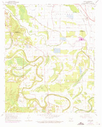
1971 Map of Tarry
USGS Topo · Published 1973About this map
Bayou Bartholomew winds through this section of Lincoln Co and Jefferson Co, its deep loops creating a complex drainage network of secondary brakes and bayous. In the early 1970s, this landscape was defined by its agricultural and riverine character, with numerous rural congregations and burial grounds serving the dispersed communities. Settlements like Tarry, Tamo, and Yorktown are connected by local roads and the Missouri Pacific railroad line, while several family and community landmarks such as White Church (Cem) and Marzel Cem are clearly indicated. The survey highlights the intersection of human settlement and the natural environment, noting features like the Indian Mound near Bethlehem Ch and the extensive marshlands of Hastings Brake and Beaver Brake. This period shows the region before more modern infrastructure changes altered the traditional rural layout of the Arkansas Delta.
Find a feature on this map
39 named features on this map. Tap any name to fly to it.
Don’t see what you’re looking for? This feature index may not catch every label — zoom into the map to look around manually.
Map Details
Editions of this 1971 Tarry Map
This is the sole edition of this map. No revisions or reprints were ever made.
Other maps of this area

1935 · Feenyville
USGS Topo · 1:62,500

1935 · Varner
USGS Topo · 1:62,500

1935 · Noble Lake
USGS Topo · 1:62,500

1935 · Rotan
USGS Topo · 1:62,500

1948 · Helena
USGS Topo · 1:250,000

1950 · Helena
USGS Topo · 1:250,000

1953 · Greenwood
USGS Topo · 1:250,000

1955 · Helena
USGS Topo · 1:250,000

1956 · Greenwood
USGS Topo · 1:250,000

1959 · Helena
USGS Topo · 1:250,000