
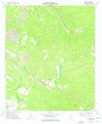
1973 Map of Tarversville
USGS Topo · Published 1977About this map
Tarversville serves as the central hub of this Middle Georgia landscape, situated at the intersection of rural routes and the Southern railroad line. The settlement pattern is defined by family-named landmarks and rural congregations, reflecting a deeply rooted agricultural community in the early 1970s. Numerous cemeteries such as Beckham Cem, Sanders Cem, and Vaughn Cem are scattered across the terrain, often adjacent to local houses of worship like the Greater New Hope Ch and Mt Olive Ch.
Find a feature on this map
35 named features on this map. Tap any name to fly to it.
Don’t see what you’re looking for? This feature index may not catch every label — zoom into the map to look around manually.
Map Details
Editions of this 1973 Tarversville Map
This is the sole edition of this map. No revisions or reprints were ever made.
Other maps of this area

1956 · Cochran
USGS Topo · 1:62,500

1956 · Perry
USGS Topo · 1:62,500

1956 · Warner Robins
USGS Topo · 1:62,500

1956 · Jeffersonville
USGS Topo · 1:62,500

1957 · Macon
USGS Topo · 1:250,000

1958 · Macon
USGS Topo · 1:250,000

1964 · Macon
USGS Topo · 1:250,000

1973 · Hayneville
USGS Topo · 1:24,000

1973 · Warner Robins NE
USGS Topo · 1:24,000
1973 · Marion
USGS Topo · 1:24,000